I love Colorado! I spend as much time as I can out here each
year, visiting at least 2 or 3 different times. I spend most of my time in
Divide, which is west on I-24 outside of Colorado Springs, where my dad now
lives. Although I’ve been out here dozens of times, the beauty of this state
always amazes me and we always find new things to do. One of my ongoing goals
is to climb all 54 of the 14ers in Colorado. I’m not very far along, but even
if I can only get one or two per summer, I’m moving in the right direction.
This particular week is my last trip of the summer. My dad came to visit back
home in Chicago for a week, so I had someone to drive back to Colorado with,
and we have had a fun week of hiking!
I spent most of the first day acclimating and resting. It’s
been a busy summer, so it was nice to just be in the fresh air and able to do a
whole lot of nothing! It’s also hard to get going right away because my dad
lives at 9,300ft elevation, so acclimation is a must if you want to be able to
breath! I was able to say hi to the dogs and the horses and enjoy the sunshine
while it lasted, and of course, I watched tons of Olympic coverage!!
The next day we headed down to Woodland Park for breakfast
and to see what was going on. Since the fires, namely the Springer and Waldo
Canyon fires, Woodland Park and other small towns going up Ute Pass, have been
struggling to get people to come back and spend their money. The fire did not
damage WP, however, now that monsoon season is in full effect, there are storms
(rain, thunder, lightening, and sometimes hail) everyday, usually sometime
after 2:00pm, which can last a few minutes or through the night. These storms
are also causing mudslides along the burn scar, which then blocks and closes
down I-24 to and from the springs. It’s a pain, but they get is cleared fairly
quickly each time and the state is in the process of mitigating the situation
before it becomes a bigger one.
The burn scar from the Waldo Canyon fire is sad. For anyone
who has spent time out this way, you know how beautiful this area is, and how
green it normally is this time of year. The fire covered a lot of ground and
Waldo Canyon is actually closed for the next two years. That was heartbreaking
for me to hear because that was always a hike that I did at least once a year,
sometimes more. So even though the fires are gone, they will be remembered for
years to come.
 |
| View from the Crags |
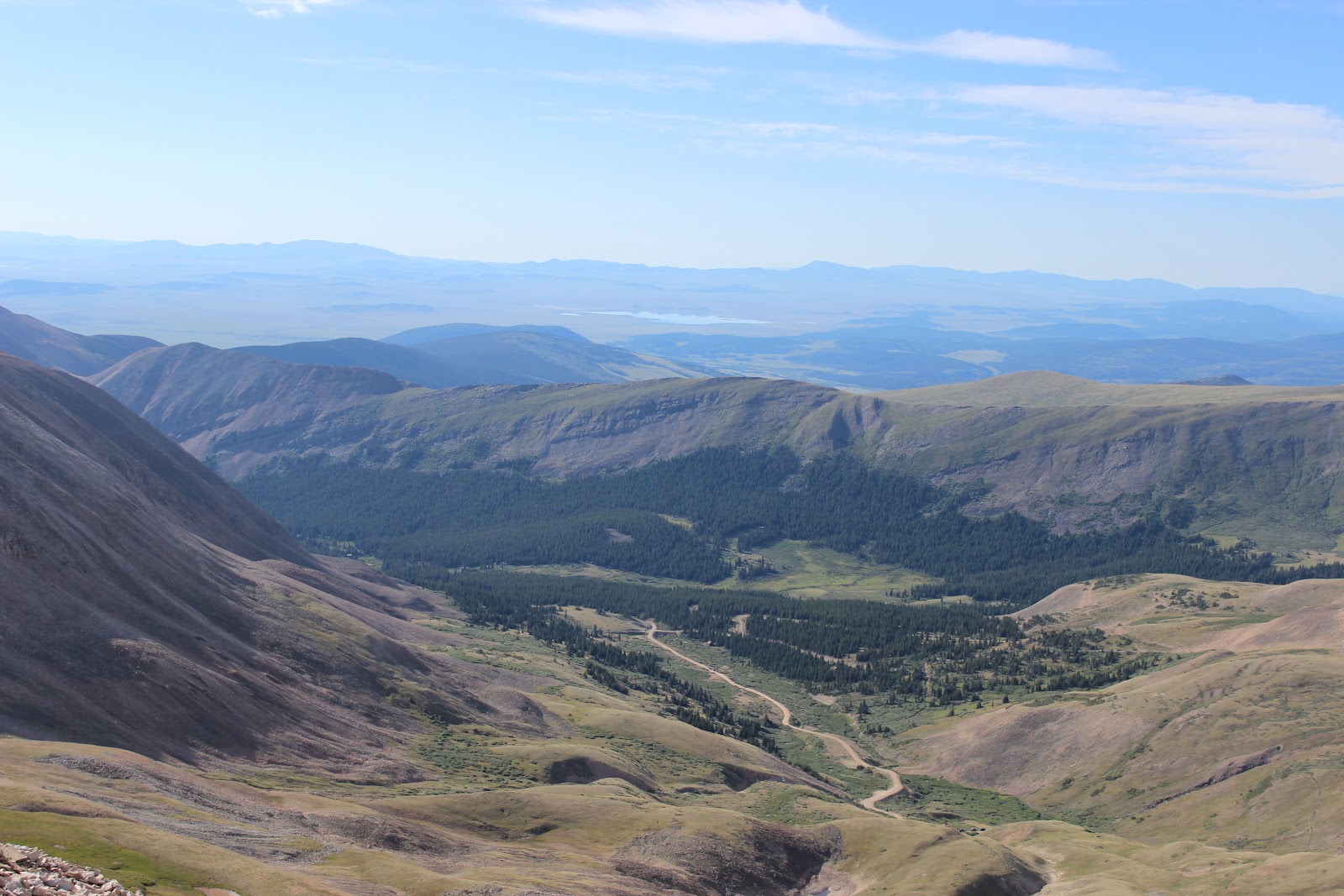
After breakfast, we decided to head to the Crags, which is a
4-5 mile round trip hike that shares a trailhead with Pikes Peak, from the backside.
This trailhead is located near the Crags campground, just outside of Divide.
The more well-known and trafficked path up Pikes Peak (one of the 14ers at
14,110ft) is the Barr Trail which starts in Manitou Springs.
 |
| Rock Formations |

 The Crags is a great hike to get acclimated because it’s
fairly straight-forward with most of the uphill hiking coming right at the end.
The elevation gain isn’t enormous, maybe 1,500ft max. I was sucking wind a
little bit, as you end up at about 11,000 feet of elevation, but man is it worth
the climb! And it’s a great way to acclimate. The views from the Crags are
awesome though! You can see Woodland Park and Divide from above, as well as
many of the surrounding mountain ranges in the west and southwest of Colorado.
We started from the “newer” trailhead, which adds another mile or so to the
hike and adds a lot of tough uphill hiking. However, we came back through the
campground, cutting off the newer trailhead, and walking down the road back to
the car. Either way works, but if you get a chance to check out this hike, do
it!
The Crags is a great hike to get acclimated because it’s
fairly straight-forward with most of the uphill hiking coming right at the end.
The elevation gain isn’t enormous, maybe 1,500ft max. I was sucking wind a
little bit, as you end up at about 11,000 feet of elevation, but man is it worth
the climb! And it’s a great way to acclimate. The views from the Crags are
awesome though! You can see Woodland Park and Divide from above, as well as
many of the surrounding mountain ranges in the west and southwest of Colorado.
We started from the “newer” trailhead, which adds another mile or so to the
hike and adds a lot of tough uphill hiking. However, we came back through the
campground, cutting off the newer trailhead, and walking down the road back to
the car. Either way works, but if you get a chance to check out this hike, do
it!  |
| Climb to the summit of Raspberry Mtn |
The following day, we decided to climb Raspberry Mountain.
This was a new hike for me, but it begins near the Crags trailhead, so it’s
convenient to get to. We decided to take three of the dogs to get them some
exercise. This hike was scheduled to take about 3 hours round-trip, although
I’m not sure of the exact distance. It was a tough hike though! Holy crap! This
hike was uphill and then back down, and up again. It’s the type of hike I like
to call a “mind-fuck”. Maybe not the best description, but very true. Just when
you think you are making headway and going uphill, the darn thing goes back
down and beats up all the work that you just put in. Either way, we made it to
the top in decent time.
 |
| The Crags from Raspberry Mountain |
 |
| Dad with Kaj and Thai |
The only one that we were worried about getting up was
Cheyenne, one of the yellow labs. She’s a big girl these days, so she was
taking her time, actually hiking behind me at times…but she made it to the top
to get her drink and treat. On the way down, she would walk ahead a bit and lay
down in the shade until we caught up and made her keep moving. It was
entertaining if nothing else! Kaj (border collie) and Thai (cattledog) made it
with ease, as they are younger and have a ton of energy. They were ready for a
nap when we got back though.
 |
| Divide from Raspberry Mountain
The views from the top are much like the Crags, but great.
You can actually see the Crags behind you from this position. Once again we
were just below 11,000 feet, so we could see everything in nearby mountain
ranges, as well as the storm heading towards the area.
|
We went to Lake George Pizza for dinner that night. It’s a
place that I had never been, but had seen many times before driving to and from
the back range and Buena Vista. Dad and I shared a chicken ranch pizza, and
headed home before the storm got too bad. The lightening was wicked, but it was
kind of cool to watch at the same time.
The next day was a rest day. Dad had some things to deal
with for football, which he still coaches, even though he is retired from
education. We watched Olympics, took care of the animals, and made a great
dinner before the next day, on which we planned to climb a 14er.
 |
| Dad on the Summit-- Mt. Sherman, 14,036 f
Wednesday was our climbing day, so we were up at 4:00am to
head towards Fairplay and Mt. Sherman. We got on the trail just before 6am and
headed to the top of the mountain. Mt. Sherman is a 14er that takes you as high
at 14,036 feet. The hike starts above 12,000ft and tree line, so we started out
climb as the sun was coming up, but it was cold and because we were starting at
such a high altitude, I was out of breath before we even got out of the car! Oh
well…here we go!
|
 |
| Old Mine |
 |
| Leadville form the summit |
There are a few old mines along the trail, which give the
trail character and something to look at while you hike. It’s wasn’t a tough
hike for the first couple of miles, but the altitude definitely made it more
difficult! When you really start hiking upward, you are on rocks, so you have
to watch where you are going with every step or you could easily twist an ankle
or just trip yourself (which I’m really good at!). So enjoying the scenery
doesn’t really happen unless you stop or get to the saddle to see where you
are. It was a beautiful clear morning,
so there were great pictures to be had!
As we neared the summit, we passed the only group ahead of
us, so we were the first to summit that morning, right at 2 hours of hiking. It
was a great feeling. From the top you can see Leadville in one direction and
Fairplay in the other. It definitely gives you a different perspective when you
are standing over 14,000 feet in the air. Dad was pointing out some of the
other 14ers, but he points at a mountain and I see four out in front of me…I
guess it’s worth trying to figure out?!
 |
| The spine to the summit |
 I kept my camera out on the way down the mountain, to get
some nice shots of the area. We decided to take a different trail down, which
ended up being mostly dirt and some loose gravel, and was steep enough that we
had to slide sideways for quite a ways down. It is a new trail that people can
take up to the saddle and skip the switchbacks, but it’s a steep one! I can’t
imagine how bad your legs would be burning if you wanted to hike up it!
I kept my camera out on the way down the mountain, to get
some nice shots of the area. We decided to take a different trail down, which
ended up being mostly dirt and some loose gravel, and was steep enough that we
had to slide sideways for quite a ways down. It is a new trail that people can
take up to the saddle and skip the switchbacks, but it’s a steep one! I can’t
imagine how bad your legs would be burning if you wanted to hike up it!
We made it down and cut off over a mile of the hike down,
took a few pictures of the old mines, and headed back to the car. There were
quite a few groups heading up at this point, and I’m hoping that they all made
it up in good time!
 |
| The trail we slid down... |
 |
| Leadville from the saddle |
[When hiking 14ers, one of the general rules is that you
want to be off of the summit by noon. Knowing that the storms come in the early
afternoon, you want to try to get to tree-line before then, so that you aren’t
caught in any lightening in the rocky areas at the top.]
After the hike, we headed into Fairplay to grab a quick bite
to eat at the Brown Burro. I had huevos rancheros, which were awesome! Fairplay
is a small town, in Southpark County, mostly known for it’s older area of town,
which the animated cartoon “Southpark” is modeled after. You can walk or drive
through this part of town. There’s not a whole lot going on there, but
something to see!
The following day, we headed down into Colorado Springs to
run some errands. We stopped at Costco and Barnes and Noble. I needed to get to
the bookstore for some research material for a trip I’m planning for next
summer. (I’ll tell you where I’m going once it’s confirmed! But I’m very
excited about it!!)
 |
| Lizard Rock |
 |
| Cheyenne taking a break |
 |
| Lizard Rock |
The next day we checked out a hike back in the Tarryall
area, which was a new hiking area even for dad. We took the hike to Lizard
Rock. It’s a rock area that looks like an iguana laying across the top.
Overall, it was probably 4-5 miles round trip. The hike wasn’t too difficult,
but it was good just to get some distance under my feet and seem some more
beautiful scenery. It was also an opportunity to get the dogs exercised again.
It was a similar scene for Cheyenne, but the other two had a great time chasing
chipmunks and running through the open fields. They also had a chance to swim
in the river on the way back.
 |
| Cheyenne and Kaj swimming |
 |
| Tarryall area |
That afternoon, we went back down to the Springs so that dad
could look for some new hiking boots, and we checked out Nico’s (my step-brother)
new work area. After finding his boots, and grabbing a cute shirt and skirt,
whose proceeds benefit the rebuilding of Waldo Canyon, we stopped at Johnny’s
Navajo Hogan. This is an old, but famous bar in Colorado Springs. It is
actually a National Historic Site and is built around an old native Indian
Hogan. It was pretty cool, lots of beer to choose from, and actually served me
my first beer in this trip! Pretty good for me! Ha!
 |
| Tarryall Area |
 |
| Tarryall Area |
 |
| What dad named "Butt Crack Rock" |
 |
| Top of the hike |
From there we dropped Nico off to grab his car and we made a
stop at Trinity Brewing. This is a great brewery off of Garden of the Gods
Road. We had a few appetizers and beers, even getting a chance to be some of
the first to try their new pilsner that they tapped while we were sitting
there. Lucky us! As it was getting later, dad and I headed back up the pass and
stopped at Bier Works in Woodland Park for one last beverage. It had been a
good and productive day, but it had also been long and busy, so it was time to
head back, watch some Olympics and get to bed!
For the last day, we just decided to relax and putz around
Woodland Park. They were having a wine festival, which we chose to bypass for
the Mountain Arts Festival. It was a nice day to just walk around, enjoy the
fresh air and see what people had to offer. We also had brunch at the Crystola,
which is a great bar just east of Woodland Park. Usually we have prime rib at
the Crystola and listen to great live music on Friday nights, but with
everything else going on, we opted for a mimosa and brunch. There is never a
bad time to go to the Crystola!
Colorado absolutely is a beautiful state. Lots to see and do year round! Your pictures are awesome. Tell your dad I like the hat :)
ReplyDelete